Introduction:
In an era where technological advancements are transforming numerous industries, LiDAR and GPS stand out as two ground-breaking technologies that have revolutionized the way we navigate and interact with our surroundings. LiDAR (Light Detection and Ranging) and GPS (Global Positioning System) have not only enhanced our ability to pinpoint locations with remarkable precision but have also opened up a world of possibilities in fields ranging from autonomous vehicles to environmental monitoring. In this blog, we will delve into the fascinating world of LiDAR and GPS technology, exploring their principles, applications, and the impact they are making on various sectors.
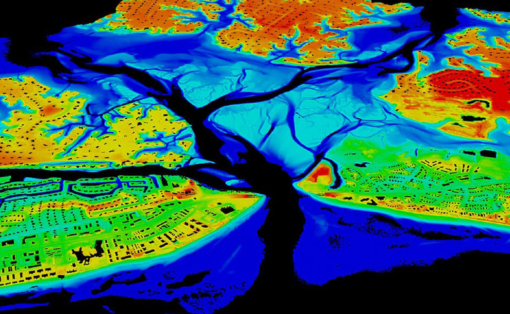
Understanding LiDAR Technology:
LiDAR technology utilizes lasers to measure distances and create detailed 3D maps of the environment. It works by emitting laser pulses and measuring the time it takes for the light to bounce back after hitting an object. By capturing millions of these laser measurements per second, LiDAR devices generate accurate point cloud data, representing the shape and location of objects in their surroundings. This technology enables a wide range of applications, including autonomous vehicles, robotics, archaeology, urban planning, and forestry management.
Applications of LiDAR Technology:
Autonomous Vehicles: LiDAR plays a crucial role in enabling self-driving cars to perceive their surroundings and make informed decisions. By providing detailed information about the distance and location of objects, LiDAR sensors assist in real-time mapping, object detection, and collision avoidance.
Environmental Monitoring: LiDAR is used in environmental research to assess vegetation health, monitor forest density, measure land surface elevation changes, and study coastal erosion. Its ability to penetrate dense vegetation and capture high-resolution data makes it an invaluable tool for assessing ecosystem health and planning conservation efforts.
Construction and Architecture: The construction industry leverages LiDAR for accurate site surveys, 3D modelling, and building information modelling (BIM). It enables architects, engineers, and construction professionals to visualize and analyse construction sites, aiding in precise measurements, clash detection, and project management.
Understanding GPS Technology:
GPS, a widely known and used technology, allows us to determine our position on Earth using a network of satellites. Originally developed for military purposes, GPS works by calculating the distance between the receiver and multiple satellites to triangulate an accurate position. The receiver then processes this data to provide real-time positioning information.
Applications of GPS Technology:
Navigation: GPS has transformed the way we navigate, whether we are driving, hiking, or sailing. It provides turn-by-turn directions, estimated arrival times, and real-time traffic information. Mobile devices and dedicated GPS units have become integral tools for individuals and businesses relying on accurate navigation.
Logistics and Fleet Management: GPS technology enables efficient logistics and fleet management by tracking the location and movement of vehicles in real-time. This aids in optimizing routes, improving delivery times, reducing fuel consumption, and enhancing overall operational efficiency.
Emergency Services: GPS has proven invaluable in emergency situations, enabling accurate and timely response. Emergency services can pinpoint the exact location of distress calls, allowing them to dispatch help swiftly and efficiently.
The Synergy of LiDAR and GPS:
While both LiDAR and GPS technology serve distinct purposes, their combination holds tremendous potential for various applications. LiDAR’s ability to generate detailed 3D maps and GPS’s accurate positioning data can be fused to create comprehensive navigation systems for autonomous vehicles, drones, and augmented reality applications. This fusion allows for enhanced localization and mapping, enabling precise tracking, environmental perception, and path planning.
Conclusion:
LiDAR and GPS have become indispensable technologies, transforming the way we perceive and navigate the world. From autonomous vehicles to urban planning and environmental monitoring, their combined capabilities are revolutionizing industries and opening up new possibilities. As these technologies continue to advance, we can expect even more innovative applications and further integration into our daily lives. The future holds immense potential for LiDAR and GPS, paving the way for a more connected, efficient, and informed world.